East Malaysia’s Key Roads: The Routes That Keep Cities and Communities Connected

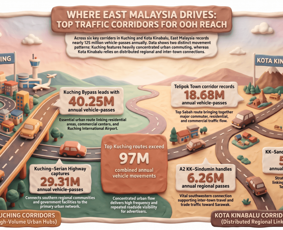
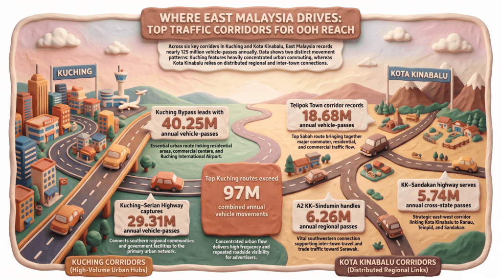
Where East Malaysia Drives: The Top 3 Traffic Corridors Powering OOH Reach in KK and Kuching.
October 21, 2026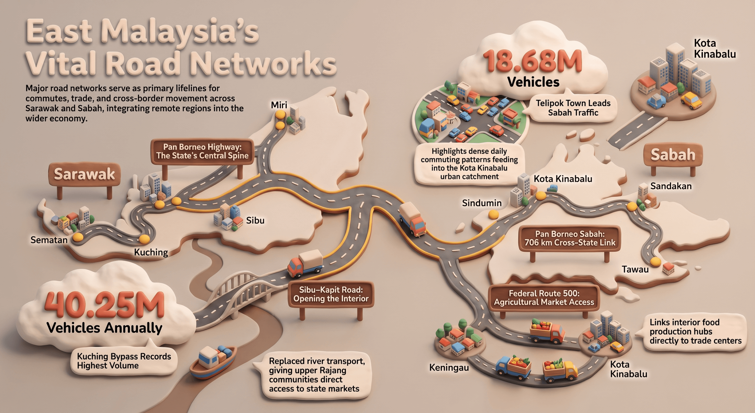
East Malaysia is connected by more than highways and city streets.
Across Sabah and Sarawak, key roads link cities with surrounding towns, communities with commercial centres, and regional hubs with markets and industries. These routes support everyday life: the daily commute, the trip to market, the delivery run and the longer journey between towns.
Here are some of the key roads that help keep Sabah and Sarawak moving.
SARAWAK
Pan Borneo Highway Sarawak: The road spine across the state
In Malaysia’s largest state, the Sarawak section of the Pan Borneo network forms one of the state’s most important long-distance road links, connecting Sematan, Kuching, Serian, Sri Aman, Betong, Sarikei, Sibu, Bintulu and Miri. It brings major population centres, economic hubs and surrounding communities into one connected land network, supporting movement between cities, industries and agricultural areas.
Kuching: The state capital and its growing catchment
Kuching–Serian Road / Pan Borneo
The Kuching–Serian route is one of the most important roads for movement between Kuching and the communities to the southeast, including Padawan, Siburan and Serian. People use the route to commute into Kuching, travel between towns, access government services and support commercial activity outside the city centre.
The scale of movement is reflected in the RTVM 2024 data, with the selected Kuching–Serian station recording 29.31 million vehicles annually. Closer to the city centre, the Kuching Bypass recorded around 40.25 million, the highest of any station in the East Malaysia dataset, reflecting how many neighbourhoods and townships feed into the capital every day.
Jalan Datuk Mohd Musa
Jalan Datuk Mohd Musa connects Kota Samarahan with Kota Sentosa and Kota Padawan, serving a growing mix of residential, education, healthcare and commercial activity. RTVM data records around 12.87 million vehicles annually, highlighting the level of everyday movement along the Kuching–Samarahan connection.
Sibu–Kapit Road: Opening the road into the interior
The Sibu–Kapit Road changed how communities along the upper Rajang connect with the wider state, providing a land route between Sibu, Kanowit, Song and Kapit where river transport was once the main link.
The road now gives interior communities more direct access to markets, services and supply networks, while helping businesses move goods more efficiently.
Jalan Lanang / Lanang Bridge
Within Sibu, Jalan Lanang and the Lanang Bridge form part of the road network connecting the town with routes towards Kuching, Bintulu and Miri, strengthening Sibu’s role as a regional centre.
Jalan Tun Ahmad Zaidi Adruce
This road links Lanang Bridge and the industrial area with Jalan Wong King Huo, Jalan Salim and the airport connection, bringing residential, commercial, industrial and airport-related movement into one urban route.
The wider network also connects into Rajang Port, adding another layer of logistics and commercial movement around Sibu. The RTVM dataset records about 13.65 million vehicles annually on the Rejang Port access road network.
Miri: Connecting the city, northern Sarawak and regional gateways
Pan Borneo Highway through Miri
Pan Borneo provides Miri with its key connection to Bintulu and the wider Sarawak road network, placing the city within the main east-west movement system of the state. This is especially important for a city whose economy combines energy, services, commerce and regional trade. The Pan Borneo route gives Miri a direct land connection with major centres farther south, while also connecting the city towards the northern part of Sarawak.
Jalan Miri–Kuala Baram
Jalan Miri–Kuala Baram extends the city’s road network towards Kuala Baram and Sungai Tujuh near the Brunei border, connecting local movement with wider regional and cross-border travel. This is a road where local city movement meets cross-border and regional movement.
Bintulu: Where urban and industrial movement meet
Jalan Tun Hussein Onn
Jalan Tun Hussein Onn is an important urban connector linking Jalan Sultan Iskandar and providing access into Bintulu’s city areas, supporting movement into the city and surrounding destinations.
Jalan Tanjung Kidurong–Samalaju Industrial Park
Bintulu’s connectivity is also closely tied to industry. Jalan Tanjung Kidurong–Samalaju Industrial Park route connects Bintulu’s industrial and port environment with the growing Samalaju industrial area, supporting movement between workers, industries, logistics and investment zones.
The Bintulu–Tanjung Kidurong road recorded about 11.58 million vehicles annually in RTVM 2024, the highest of any Bintulu station in the dataset.
SABAH
Pan Borneo Highway Sabah: Connecting the West Coast, East Coast and interior
Sabah’s Pan Borneo network provides the state’s major land connection across a much larger geography. The 706 km Pan Borneo Sabah project runs from Sindumin to Tawau, with key federal routes connecting the West Coast, northern Sabah, the interior and the East Coast.
The wider network includes the Kota Kinabalu–Sandakan route through Ranau and Telupid, as well as the eastern route through Sandakan, Lahad Datu, Kunak and Tawau.
Kota Kinabalu: Connecting the wider urban catchment
Tuaran Bypass, Jalan Lintas and Penampang Bypass
Kota Kinabalu’s connectivity depends on a network of roads extending beyond the city centre. Tuaran Bypass and Jalan Tuaran connect towards Manggatal, Sepanggar, Telipok and Tuaran, while Jalan Lintas supports cross-city movement and Penampang Bypass connects the southern urban catchment.
RTVM 2024 data records 18.68 million vehicles annually at Telipok Town, the highest-volume Sabah location in the dataset.
Federal Route 500: Kota Kinabalu–Tambunan–Keningau
Further inland, this road links the KK coastal urban centre with Tambunan, Keningau and the interior. Sabah’s agriculture planning continues to focus on districts including Tambunan and Keningau for rice and wider agricultural production, which makes the road an important connection between interior production areas and the larger Kota Kinabalu market.
Sandakan: Connecting the city with surrounding communities
Jalan Labuk
Jalan Labuk connects Sandakan with surrounding areas including Sepilok and Gum-Gum, creating an important link between the urban centre and communities beyond the city.
Its role extends beyond through-traffic, supporting movement between residential areas, businesses, tourism destinations and Sandakan town.
Jalan Utara / Jalan Lintas Utara
Closer to the city, Jalan Utara and Jalan Lintas Utara form important internal links connecting neighbourhoods such as Taman Indah Jaya, Tinosan, Kim Fung, Bandar Maju and other residential areas with the town bus station. These roads provide important links between residential neighbourhoods and Sandakan’s town centre, supporting everyday urban movement.
Tawau: Connecting the East Coast
Tawau–Semporna Road
The Tawau–Semporna route is an important regional connection between Tawau, Semporna and the wider East Coast network, supporting both inter-town and longer-distance travel. It forms part of the broader east-coast road system that links Tawau, Kunak, Lahad Datu and Sandakan.
RTVM data also records 4.06 million vehicles annually at a monitoring point near Balung Junction, providing a view of recurring movement along this wider network.
Jalan Apas
Closer to Tawau, Jalan Apas connects the town with surrounding communities and agricultural areas, supporting daily movement into and out of the urban centre.
What these roads tell us about East Malaysia
Across Sabah and Sarawak, major roads do more than move vehicles from one place to another.
They connect:
Cities → towns → communities
Homes → workplaces → commercial centres
Farms → markets → ports
Industrial areas → logistics networks
That makes the road network an important part of understanding how people, commerce and communities move across East Malaysia.
For media planning, this movement also provides useful context. Roads that connect residential areas, commercial centres and regional destinations naturally become part of the everyday journeys of road users — helping planners understand where media environments sit within wider patterns of movement.
East Malaysia’s roads are more than routes on a map. They are the links between cities, communities, commerce and everyday life.
Source: Road Traffic Volume Malaysia (RTVM) 2024 | DMDC Media analysis of East Malaysia road traffic data